The ever-excellent Google Maps mashup Google Pedometer has recently added an “elevation” feature, allowing you not only to see how far you walked, ran, cycled, or drove, but also to see how far up and down you went along the way. You simply click the “elevation” link and it displays a scrolling iframe with your entire route plotted out as a long horizontal graph.
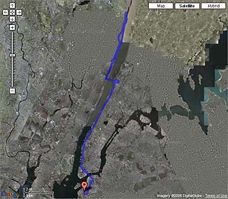
I did a 50-mile ride yesterday, most of which somehow ended up being in 15mph headwinds. Ouch! When I got home, I fired up the computer and plotted my course.
Here’s the best part of my ride: Immediately following the highest point of my entire route, there was a thrilling mile-long descent right down to the lowest point, a riverside pier in Alpine New Jersey. Four miles later, a steep continuous climb brought me (almost) back up again. (click below to see the whole graph).

I’ve been out of practice lately due to my workload and other lame excuses, but it was great to get out and feel the pain on such a beautiful, perfect day for cycling. And there’s something satisfying about seeing the hills displayed this way — not only does it give a real sense of accomplishment (I can pretend these are the French Alps!), but it also gives me some insight into the overall “lay of the land” for the next time I take this route. What a great tool.
UPDATE: I also made a graph of the Prospect Park loop, starting and finishing at the Grand Army Plaza entrance.
Comments
7 responses to “Reaching Higher Ground with Google Maps”
Yeah google and yahoo made an update to the Maps Services,
soon we will see my car from online maps, altrough i`m from Central Europe.
The competition is big Msn, Yahoo, Google constantly try to give better products, but always Google has a step in front of all.
i’ve been biking mainly for transportation (freelancing around brooklyn) but have done that loop once or twice (in fits of moral-building exercise). that last part of the loop from pt. 3 to the plaza again is killer! but good to see google maps confirming that.
If you really want to geek out, get a Garmin Forerunner (the 301 is down to $95 now), which will map your ride for you when you return. Here’s a recent ride I did on the same route (River Rd/9W to the Runcible Spoon in Nyack). If you’re using Win IE play with the Map Player which will let you animate the route showing a marker corresponding with elevation profile, % grade, speed, heart rate and zone. I wasn’t wearing the HRM strap on that ride.
They pack a lot of data into that visualization. I find that it’s actually too much, but I really dig being able to visualize the ride and see what my level of effort was even if the user interface is a bit noisy.
Michael: Holy crap, that’s pretty amazing data. The temperature too? Wow. I think the last time I met you you were showing off your PDA phone — at least you are consistent with your gadget geekery!
I wish there was a way to see elevation while planning routes for bike trips.
@Tony: The first link on this page, to the Google Pedometer, will do what you want.
Yes, what technology will do with sports! I came to this site because I am trying to find some answers how to get elevation from Google maps. I think the elevation is taken from another provider, but I’ll check it out. thanks