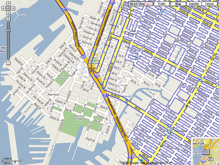
I love Google Street View. But what a surprise I had when I tried to view my own building and found out that the Street View photo-truck decided that they would limit their coverage to upscale (i.e., white) neighborhoods.
The blue outlined streets show where Google Street View is operative. I live in the non-blue area, a Brooklyn neighborhood called Red Hook. Red Hook is a predominantly black, mostly low-income neighborhood. And Google literally left us off the map with the same diligence of a 19th-century political boss carving out a gerrymander.
By all accounts, and despite its historical economic stagnation, Red Hook is the next Williamsburg (where I lived for ten years until the rich kids priced me out!), which means that I am not immune to accusations of gentrification and all that baggage. But that’s just all the more reason to be surprised and disappointed at Google’s completely irrational and unethical fear of “bad neighborhoods”.
Google Street View did a drive-by of our area (Prospect Heights). We got partially covered by major conduits — they snapped Eastern Parkway, Washingtion Ave, Atlantic Ave, etc.. They even drove well into Crown Heights and Cypress Hills… all down major conduits and highways, but no actual side streets.
Will they late weave in and out of those neighborhoods in more detail? Who knows? But it certainly has a certain Robert Moses-esque bite to it.
Good call, Noah. The BQE/Gowanus elevated highway is the Moses-conceived barrier that has long been the de facto good neighborhood/bad neighborhood border. It’s no surprise, I guess, that the Google people avoided crossing this border in the same way that everyone else has for decades. It’s basically a Berlin Wall.
On second look, it looks like they also avoided the heart of Carroll Gardens (the side streets off of south Court), which is admittedly pretty upscale and pretty white. They also haven’t gotten to the nicest parts of Park Slope, either.
Yeah, but can I walk through Times Square in 1880? Maybe see the gerrymandering first hand? 😉 Maybe someone in the future will be able to walk down Broadway or Union Street in 2007. Not sure what the value is except thinking about walking around turn of the century New York would be really cool.
We heard someone in 1995 talking about doing this during a lecture at FIS in Toronto. And it wasn’t Google. Guess we know what happened to that project.
Thanks, Chris Fahey.
Christian
I have been apartment hunting in San Francisco, and I found the same thing. Google. Street View has nothing in Visitacion Valley, which is primarily black, hispanic and filipino.
Comments
6 responses to “The Google Street View Racial Gerrymander”
I love Google Street View. But what a surprise I had when I tried to view my own building and found out that the Street View photo-truck decided that they would limit their coverage to upscale (i.e., white) neighborhoods.
The blue outlined streets show where Google Street View is operative. I live in the non-blue area, a Brooklyn neighborhood called Red Hook. Red Hook is a predominantly black, mostly low-income neighborhood. And Google literally left us off the map with the same diligence of a 19th-century political boss carving out a gerrymander.
By all accounts, and despite its historical economic stagnation, Red Hook is the next Williamsburg (where I lived for ten years until the rich kids priced me out!), which means that I am not immune to accusations of gentrification and all that baggage. But that’s just all the more reason to be surprised and disappointed at Google’s completely irrational and unethical fear of “bad neighborhoods”.
Google Street View did a drive-by of our area (Prospect Heights). We got partially covered by major conduits — they snapped Eastern Parkway, Washingtion Ave, Atlantic Ave, etc.. They even drove well into Crown Heights and Cypress Hills… all down major conduits and highways, but no actual side streets.
Will they late weave in and out of those neighborhoods in more detail? Who knows? But it certainly has a certain Robert Moses-esque bite to it.
Good call, Noah. The BQE/Gowanus elevated highway is the Moses-conceived barrier that has long been the de facto good neighborhood/bad neighborhood border. It’s no surprise, I guess, that the Google people avoided crossing this border in the same way that everyone else has for decades. It’s basically a Berlin Wall.
On second look, it looks like they also avoided the heart of Carroll Gardens (the side streets off of south Court), which is admittedly pretty upscale and pretty white. They also haven’t gotten to the nicest parts of Park Slope, either.
If you want to see something really amusing, Google Maps caught my friend Steve going to the Lone Star (it’s a bar in SOMA SF)
http://tinyurl.com/yv2cc8
Big brother *is* watching.
Yeah, but can I walk through Times Square in 1880? Maybe see the gerrymandering first hand? 😉 Maybe someone in the future will be able to walk down Broadway or Union Street in 2007. Not sure what the value is except thinking about walking around turn of the century New York would be really cool.
We heard someone in 1995 talking about doing this during a lecture at FIS in Toronto. And it wasn’t Google. Guess we know what happened to that project.
Thanks, Chris Fahey.
I have been apartment hunting in San Francisco, and I found the same thing. Google. Street View has nothing in Visitacion Valley, which is primarily black, hispanic and filipino.