I’m getting some traffic today from kottke, so I figured I’d actually show y’all what the heck it is he’s talking about when he wrote:
The first time I saw a world map drawn from memory was at Christopher Fahey’s apartment. I forget how long it took him to draw, but it was remarkably accurate and fairly large (a few feet across).
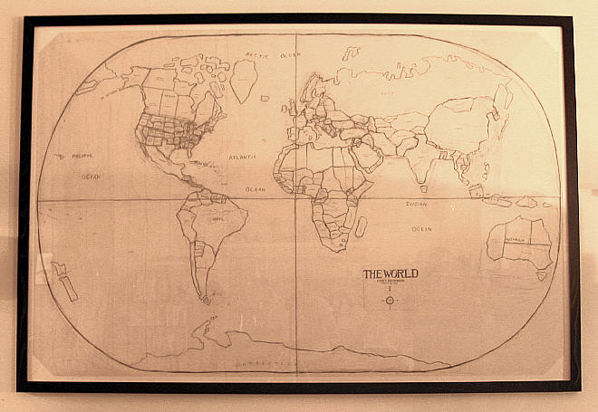
So there it is. This is a photo I took just tonight of the map, hanging on the wall of the aforementioned apartment. It’s about four by six feet, entirely in pencil, and I made it over the course of about two weeks in 1993 during my senior year at Cooper Union. During those two weeks, I studiously avoided looking at maps on posters or in newspapers, to ensure that each time I resumed working on the map I would not have artificially pumped myself full of fresh map knowledge. The result is a map not just using my memory, but also using the added elements of (a) time and (b) the basic techniques of drawing.
UPDATE: Some answers to questions, and some added insights:
- The biggest thing I missed was Bolivia. I missed two other, poorer, countries whose names I can’t remember. Otherwise, I got ’em all (that is, they’re all on the map — they might not be in the correct place, of course!). Oh, and I missed some Canadian provinces — Canucks always ding me for that.
- I got all the former Soviet Republics because they were all mentioned in the news in 1993. Likewise for the Balkans.
- I am most embarassed by the shapes and positions of China, Japan, and the Koreas. I really got them wrong, comparatively.
- The North coast of Russia and Canada are almost completely made up. Except for the island/peninsula thing on Russia, which I think is called Nova Zemblya (or maybe that’s the name of the country from Nabokov’s Pale Fire).
- Ironically, you can tell which parts I made up because they have the smallest number of erasures. I just drew them once and was done with it. Look at Antarctica, Greenland, or anywhere in central Asia. I had no hope of getting them right, so I just guessed.
- Conversely, the parts of the map that do have a lot of corrections (the US states, the positioning of Japan) are the parts where I obviously did a lot of thinking and rethinking to get it just right. In these cases, I ultimately had some confidence that I would find the right answer..
- Many of the countries and states were “remembered” by the fact that there was negative space still remaining between the countries I knew and the ones I did not. For example, I had no idea Pakistan had a coastline (I’d assumed it was landlocked) until I drew the map and thought to myself there was no way that Iran bordered India. Thus, my drawing of Pakistan reaches the sea, just as the real Pakistan does. This is very much like putting together a puzzle.
- Sometimes some simple factual “rules” help, too, things that I know because I made a mental note of it at some point in my life. For example, I know that the west coast of South America lines up with the East Coast of North America. Or that the northwest bulge of Africa is above the equator.
- I once owned a world map shower curtain. And yes, I am a freak about maps and am always consciously and subconsciously memorizing something every time I see one.
Comments
41 responses to “My Map from Memory”
I can’t believe you let Kottke into your apt.
The map rocks btw
😉
Now thats impressive, It looks just like any other map of the world I ever saw, except all the others are studied from ordinance survey pictures.
Nice work – did you discover any glaring errors after you’d finished and compared it to the real thing?
wow, that’s amazing! Are you some kind of rain man? In fact it’s almost suspiciously good, especially the north coast of russia, but I see you just made up the top canadian islands.
you rock, chris! wow!
Dude…Texas is SO BIG.
And rightly so.
wow. good job. my biggest problem would be to determine the limits of african countries. i think i could do a good job with the outline of all the continents but getting the countries right would be almost impossible.
poor brasil lost its leg, it looks a bit odd. italy is always the best one to draw. 😉
Have another look at Australia. Your rendition is hilarious to an Australian.
[…] Here’s a really cool world map hand drawn from memory as a lark, and the story behind it. This site belongs to an artist, designer and teach Christopher Fahey. It’s worth spending some time browsing through his site graphpaper.com, he surfaces a lot of interesting ideas and thought provoking topics. […]
Well you have missed at least one European country.
@Mikael: No, I didn’t.
Have another look at Brazil. Your rendition is hilarious to a brazilian.
🙂
“Have another look at Brazil. Your rendition is hilarious to a brazilian.
:)”
Same with The Philippines! You reduced our 7,100+ beautiful islands to 3 lumps of dog poop.. Haha..
In fairness, you’ve done better than I could ever hope with that map.. Kudos.
GOD YOU HAVE SO MUCH TIME!!!!!!!!!!!!
[…] Persone con capacità mnemoniche fuori dal normale: Christopher Fahey e la sua mappa del mondo disegnata a memoria (Via: Kottke). Il gruppo Flickr From Memory (da cui “My Anatomy From Memory“, l’immagine in basso). Qui un’originale mappa del sistema solare. Lori Napoleon colleziona disegni a memoria di varie persone. Il Global participatory “Fool’s world Map” project”. Mappe dettagliate dalla memoria di ragazzini delle elementari. Lo straordinario senso eidetico di Stephen Wiltshire e i suoi disegni di Tokio e Roma (video YouTube). Leggi “L’uomo che scambiò sua moglie per un cappello” (Oliver Sacks). Ripeti “Silvia rimembri ancora quel tempo…” […]
hello chris,
i have just finished a residency in glue gallery in newcastle upon tyne. i proposed to draw a map of newcastle upon tyne uk from memory and anotate it with memories and places along the way. it was accepted, i also abstained from looking at any maps before the completion of the work. it may not have the enormity of the world but it was some task. if you send me an email i can send you pictures of the piece. well done on your effort, ben
littleotik@hotmail.co.uk
Well done! I had a similar assignment when I was in middle school. You di much better than I did, though!
I am interested in the topics discussed but have been feeling a little intimidated by the thought of the work
beautiful!
i’m just about to embark on a performance art project of drawing maps of local areas on the pavement in chalk with the help of the memories of passers-by. am rather nervous… just looked up ‘drawing maps from memory’ in google for some support – and here you are. made me feel good that such a beautiful thing came out of a bit of time & dedication. thanks.
Man, just what did you do to the true north, strong and free. I mean it’s impressive what you did but Canada, does not look like that. Good job on the rest of it though. Wish i had thems 1337 /\/\ 4 |^ 5|
I think the idea of writing a song about a great cms is nice and the final song is amazing!!
ya missed borneo
!
Excellent work. Hint for next time: Ecuador means “equator”.
@Adrian: Yes, that was pretty dumb of me. I think I had in my mind some kind of kooky idea that it was paradoxically not on the equator.
You did a great job doing the map, it looks beautiful!
You did a great job doing the map, it looks beautiful!
you rock, chris! wow!
hay!!
good project 🙂
senks 🙂
I’m impressed that you remembered Lesotho and Swaziland in South Africa. Well done. I think you may have gotten their position a little wrong, but kudos to you! This is really, very cool. Well done. If you could do it ONE TIME that would be cool– and impossible. But this is just as cool, and probably makes for a fantastic picture in your house. I really like the style – I wouldn’t mind hanging one of these in my house.
Well done, this is incredibly impressive. I think that this was a great idea, something I’m definitely going to think about doing soon. Having a big map like this in your living room on a large wall would really look excellent – it would be a wonderful design piece. And, plus, you could tell all your new friends who come over what the story behind it is. Great idea, really great idea.
Kottke inside your apartment???!!! Wow! You are one of the luckiest people here on Earth! The map is so cool! Is it possible for virtual people like me work on something like that, too? If yes, please share with us the procedure.
My neice and nephews school requires every student to do that in the 8th grade. I might try it, too
good article. thanks you
Great look , good job.
If you could do it ONE TIME that would be cool– and impossible.
New Zealand looks fat and retarded
New Zealand looks very fat and retarded. You suck 🙂
You suck at drawing. And plus my email address is fake. Well its not fake but I just forgot the password
Good work
but I have devised a way to draw the entire world map from memory and all the 203 countries on it exactly. And I have taught this to my children 8 and 9 years old.
The system is so solid that you cannot forget. The only thing you require is to have some familiarity with the name of the countries of the world.
And there are no wiggly lines for a change. I have straightened them with some loss of accuracy but not much.
You can always find out the neighboring countries and whether the country is landlocked or not or which sea comes next to it etc.
Contact me at 2sidsinha@gmail.com
Sid
That’s pretty impressive. The general shapes, sizes, and positions of the continents are extremely accurate.